Writing GPS EXIF information #6657
Comments
|
Could you upload a copy of image_with_exif.JPG? And perhaps 155.jpg for comparison? |
|
@radarhere sure: Also zipped, since I don't know if GitHub pre-processes images that are uploaded: |

|
Inspecting image_with_exif.JPG with exiftool, I see that the GPS data is not just present within the EXIF IFD, it is also written as XMP data. So, I've tried modifying your code to also write the GPS data as XMP. The following is the code I inserted, and you can see the full version and the generated image here - xmp.zip import struct
data = b'http://ns.adobe.com/xap/1.0/\x00<?xpacket begin="?" id="W5M0MpCehiHzreSzNTczkc9d"?>\n<x:xmpmeta xmlns:x="adobe:ns:meta/">\n<rdf:RDF xmlns:rdf="http://www.w3.org/1999/02/22-rdf-syntax-ns#">\n<rdf:Description exif:GpsLatitude="%f"\nexif:GpsLongitude="%f"\nexif:AbsoluteAltitude="%f">\n</rdf:Description>\n</rdf:RDF>\n</x:xmpmeta>\n<?xpacket end="w"?>\n' % (lat, lng, alt)
size = struct.pack(">H", 2 + len(data))
app1 = b"\xFF\xE1" + size + data
image.save(image_path, exif=exif, extra=app1)However, I don't have a Windows machine to check. Does it detect the GPS information from the file now? |
|
@radarhere Thanks a lot for your help! Unfortunately, the GPS data is still not available. Neither in the provided image from the zip file nor, when I am adapting my source code based on your additions.
|

|
Comparing the exif data, respectively the GPS IFD information, from the originally geo-referenced image (first and second json) and the manually one using Pillow (third and fourth json), I don't see big differences except of the XMP data and some additional (hopefully optional) properties? {296: 2, 282: 72.0, 34853: 590, 34665: 260, 270: 'WhiteHot', 271: 'DJI', 272: 'M30T', 305: '10.00.38.17', 274: 1, 306: '2022:10:05 10:08:42', 531: 1, 283: 72.0, 40092: b'0\x00.\x009\x00.\x001\x004\x002\x00\x00\x00\x00\x00\x00\x00\x00\x00\x00\x00\x00\x00\x00\x00\x00\x00\x00\x00\x00\x00\x00\x00\x00\x00\x00\x00\x00\x00\x00\x00\x00\x00\x00\x00\x00\x00\x00\x00\x00\x00\x00\x00\x00\x00\x00\x00\x00\x00\x00\x00\x00\x00\x00\x00\x00\x00\x00\x00\x00\x00\x00\x00\x00\x00\x00\x00\x00\x00\x00\x00\x00\x00\x00\x00\x00\x00\x00\x00\x00\x00\x00\x00\x00\x00\x00\x00\x00\x00\x00\x00\x00\x00\x00\x00\x00\x00\x00\x00\x00\x00\x00\x00\x00\x00\x00\x00\x00\x00\x00\x00\x00\x00\x00\x00', 40094: b's\x00i\x00n\x00g\x00l\x00e\x00'}{0: b'\x02\x03\x00\x00', 1: 'N', 2: (48.0, 22.0, 12.2717), 3: 'E', 4: (14.0, 30.0, 47.8458), 5: b'\x00', 6: 563.874, 9: 'A', 18: 'WGS-84\x00'}{296: 2, 282: 72.0, 34853: 344, 256: 1920, 257: 1080, 258: (8, 8, 8), 262: 2, 34665: 290, 271: 'Manufacturer', 272: 'Camera', 305: 'Adobe Photoshop 22.1 (Windows)', 274: 1, 306: '2022:10:12 08:54:47', 277: 3, 283: 72.0}{0: b'\x02\x03\x00\x00', 1: 'N', 2: (48.0, 22.0, 12.271700000012515), 3: 'E', 4: (14.0, 30.0, 47.84580000000034), 5: b'\x00', 6: 563.874, 9: 'A', 18: 'WGS-84\x00'} |
|
Ok, I'll try again, this time just copying all of the XMP data. Does this image work?
|

|
@radarhere Thanks again. Unfortunately, not. But I am still not sure if GitHub removes Exif data. Could you re-upload it as zip? :) |
|
Downloading the image again, I would conclude that it doesn't remove the Exif data, but here you go - 155.jpg.zip
So there are other programs apart from Windows File Property that are showing you this difference between the two images? What are they? |
|
Hi @radarhere, I also tried online tools like https://www.pic2map.com/. Here I managed to find out in the meantime, that it won't show the geo-referenced photos if no camera manufacturer or camera model is added within the EXIF data. For other tools, I have not figured out why the images created with Pillow are not working but the real geo-referenced images are working like:
Google Earth Pro is also struggling, but only with the altitude information. But this is also true with the real geo-referenced images, so it is probably a problem of Google Earth itself. |
|
I've figured out that Pillow is using the wrong types when saving GPS data to EXIF. It saves GPSLatitude as a double, rather than as a rational. I've created PR #6661 to fix that. This image tests out this change - out.jpg.zip. Does it work? |
|
@radarhere Thanks a lot for your support and work! The newly generated image is working perfectly fine now :) |
|
Excellent. Thanks for your quick response. So you don't need to make any changes to your original code. If #6661 is merged, then it will be part of the next release. A release is due out is about two weeks, so you may not have to wait long. If you would like to use the fix before that, you could compile Pillow from source using the branch, but that may not be simple on your Windows machine. Alternatively, if you can find TiffTags.py within your Pillow installation, you can copy the PR's changes by hand. |
|
Thanks :) I have also some Linux machines here, so no problem at all to build it manually for the moment :) |
What did you do?
I am trying to geo-reference images and for this I want to add GPS Exif data to the images.
While reading and writing using Pillow seems to work fine, the written GPS Exif Data seems to be invalid and is not accessible in other programs such as the Windows File Property overview.
What did you expect to happen?
When I write GPS Exif that it is also readable for other tools.
What actually happened?
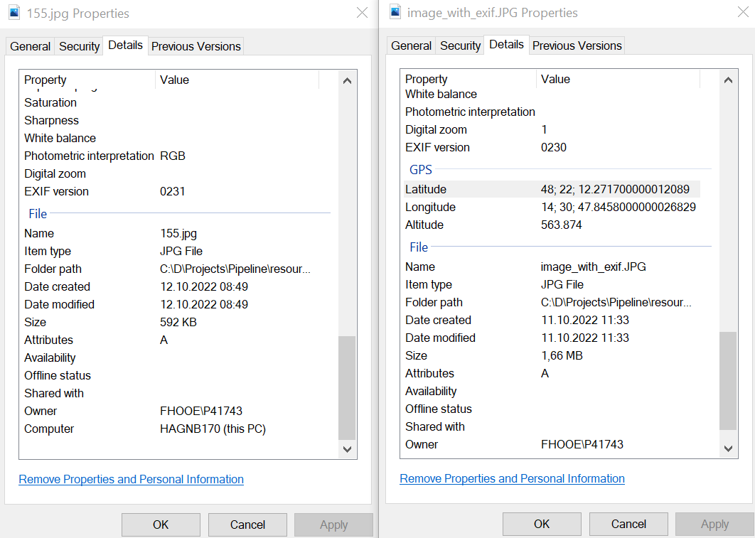
GPS Exif is not available in other programs such as Windows File Properties (left image created with Pillow; right image created with camera) :
What are your OS, Python and Pillow versions?
Sample code
The text was updated successfully, but these errors were encountered: