This plugin is a thin wrapper for Google Maps Android API and Google Maps SDK for iOS.
Both PhoneGap and Apache Cordova are supported.
- Stable version(npm)
$> cordova plugin add cordova-plugin-googlemaps \
    --variable API_KEY_FOR_ANDROID="..." \
    --variable API_KEY_FOR_IOS="..."
- Development version(beta version)
$> cordova plugin add https://github.com/mapsplugin/cordova-plugin-googlemaps#multiple_maps \
    --variable API_KEY_FOR_ANDROID="..." \
    --variable API_KEY_FOR_IOS="..."
<widget ...>
  <plugin name="cordova-plugin-googlemaps" spec="2.3.8">
    <variable name="API_KEY_FOR_ANDROID" value="(api key)" />
    <variable name="API_KEY_FOR_IOS" value="(api key)" />
  </plugin>

  <!--
    You need to specify cli-7.1.0 or greater version.
    https://build.phonegap.com/current-support
  -->
  <preference name="phonegap-version" value="cli-8.0.0" />
</widget>-
 PLAY_SERVICES_VERSION = (15.0.1)
The Google Play Services SDK version. You need to specify the same version number with all other plugins. Check out the latest version here. -
ANDROID_SUPPORT_V4_VERSION = (27.1.1)
This plugin requires the Android support library v4. The minimum version is 24.1.0. Check out the latest version here. -
 LOCATION_WHEN_IN_USE_DESCRIPTION
This message is displayed when your application requests LOCATION PERMISSION for only necessary times. -
LOCATION_ALWAYS_USAGE_DESCRIPTION
This message is displayed when your application requests LOCATION PERMISSION for always.
In order to keep this plugin as free, please consider to donate little amount for this project.
-
v2.3.8
- Hot fix: v2.3.7 does not work for iOS. Sorry about that.:pensive:
-
v2.3.7
- Update: Regenerate tbxml-android.aar with
android:minSdkVersion="19"for the developers who use older cordova verions - Fix: Can't interact with map on Android 4.4.2 if body uses ResetCSS rule
- Fix: Fixed bug in "getMyLocation" with last location result
- Fix: HtmlInfo window content not clickable if HTML structure is very simple
- Fix: MarkerCluster does not work with error "evaluating 'Object.keys(self._markerMap)'"
- Fix: Conflicting with Kendo UI framework.
- Fix: Clustered marker icons with specified dimensions reverting to default ones when redrawn [iOS]
- Update:
NSTimer scheduledTimerWithTimeIntervalcode - Fix: Map does not resize when map div is resized.
- Update: Regenerate tbxml-android.aar with
-
v2.3.6
- Fix: onPause causes app crashes on Android
- Fix: Can't find variable: element
- Fix: Can't interact with map on tutorial code
-
v2.3.5
- Fix:
cordova.fireDocumentEvent('plugin_touch', {})blocks HTML DOM tree parsing process. - Fix:
Uncaught TypeError: evt.target.hasAttribute is not a functionwhen device is rotated. - Fix:
marker.setDisableAutoPan()does not work on iOS. - Fix:
before_plugin_install.jsdoes not work very if Cordova blows off dependency package installation.
- Fix:
-
v2.3.4
- Fix: plugin does not recognize HTML elements correctly after moving HTML elements with animations
- Fix: map did not attach after coming back from stacked another page
- Fix: map does not resize when keyboard is hiding.
-
v2.3.3
- Comment out debug code (only this)
-
v2.3.2
- Update: reduce the number of times of DOM tree parse process. (= improve performance.)
- Fix:
map.getMyLocation()andLocationService.getMyLocation()do not work. - Fix: can not execute any methods of the marker obtained from
MARKER_CLICKevent of marker cluster - Fix: can not touch Div element which is moved with
css transitionover map view. - Fix: internal event does not work well with ionic 1 project.
-
v2.3.1
- Fix: incompatible with
@ionic-native/google-maps
- Fix: incompatible with
-
- New feature:
StreetView - A callback is no longer required for the most part.
Promiseis supported instead ofcallback
- New feature:

document.addEventListener("deviceready", function() {
  var div = document.getElementById("map_canvas");

  // Initialize the map view
  var map = plugin.google.maps.Map.getMap(div);


  var button = document.getElementById("button");
  button.addEventListener("click", function() {

    // Move to the position with animation
    map.animateCamera({
      target: {lat: 37.422359, lng: -122.084344},
      zoom: 17,
      tilt: 60,
      bearing: 140,
      duration: 5000
    });

    // Add a maker
    var marker = map.addMarker({
      position: {lat: 37.422359, lng: -122.084344},
      title: "Welcome to \n" +
             "Cordova GoogleMaps plugin for iOS and Android",
      snippet: "This plugin is awesome!",
      animation: plugin.google.maps.Animation.BOUNCE
    });

    // Show the info window
    marker.showInfoWindow();

    // Catch the click event
    marker.on(plugin.google.maps.event.INFO_CLICK, function() {

      // To do something...
      alert("Hello world!");

    });
  }
}, false);
https://github.com/mapsplugin/cordova-plugin-googlemaps-doc/blob/master/v2.3.0/README.md
Quick examples
 Map |
var options = {
  camera: {
    target: {lat: ..., lng: ...},
    zoom: 19
  }
};
var map = plugin.google.maps.Map.getMap(mapDiv, options) |
 Marker |
var marker = map.addMarker({
  position: {lat: ..., lng: ...},
  title: "Hello Cordova Google Maps for iOS and Android",
  snippet: "This plugin is awesome!"
}) |
 MarkerCluster |
var markerCluster = map.addMarkerCluster({
  //maxZoomLevel: 5,
  boundsDraw: true,
  markers: dummyData(),
  icons: [
      {min: 2, max: 100, url: "./img/blue.png", anchor: {x: 16, y: 16}},
      {min: 100, max: 1000, url: "./img/yellow.png", anchor: {x: 16, y: 16}},
      {min: 1000, max: 2000, url: "./img/purple.png", anchor: {x: 24, y: 24}},
      {min: 2000, url: "./img/red.png",anchor: {x: 32,y: 32}}
  ]
}); |
 HtmlInfoWindow |
var html = "<img src='./House-icon.png' width='64' height='64' >" +
           "<br>" +
           "This is an example";
htmlInfoWindow.setContent(html);
htmlInfoWindow.open(marker);
|
 Circle |
var circle = map.addCircle({
  'center': {lat: ..., lng: ...},
  'radius': 300,
  'strokeColor' : '#AA00FF',
  'strokeWidth': 5,
  'fillColor' : '#880000'
}); |
 Polyline |
var polyline = map.addPolyline({
  points: AIR_PORTS,
  'color' : '#AA00FF',
  'width': 10,
  'geodesic': true
}); |
 Polygon |
var polygon = map.addPolygon({
  'points': GORYOKAKU_POINTS,
  'strokeColor' : '#AA00FF',
  'strokeWidth': 5,
  'fillColor' : '#880000'
}); |
 GroundOverlay |
var groundOverlay = map.addGroundOverlay({
  'url': "./newark_nj_1922.jpg",
  'bounds': [
    {"lat": 40.712216, "lng": -74.22655},
    {"lat": 40.773941, "lng": -74.12544}
  ],
  'opacity': 0.5
});
|
 TileOverlay |
var tileOverlay = map.addTileOverlay({
  debug: true,
  opacity: 0.75,
  getTile: function(x, y, zoom) {
    return "../images/map-for-free/" + zoom + "_" + x + "-" + y + ".gif"
  }
}); |
 KmlOverlay |
map.addKmlOverlay({
  'url': 'polygon.kml'
}, function(kmlOverlay) { ... }); |
 Geocoder |
plugin.google.maps.Geocoder.geocode({
  // US Capital cities
  "address": [
    "Montgomery, AL, USA", ... "Cheyenne, Wyoming, USA"
  ]
}, function(mvcArray) { ... }); |
 poly utility |
var GORYOKAKU_POINTS = [
  {lat: 41.79883, lng: 140.75675},
  ...
  {lat: 41.79883, lng: 140.75673}
]
var contain = plugin.google.maps.geometry.poly.containsLocation(
                    position, GORYOKAKU_POINTS);
marker.setIcon(contain ? "blue" : "red");
|
 encode utility |
var GORYOKAKU_POINTS = [
  {lat: 41.79883, lng: 140.75675},
  ...
  {lat: 41.79883, lng: 140.75673}
]
var encodedPath = plugin.google.maps.geometry.
                       encoding.encodePath(GORYOKAKU_POINTS);
|
 spherical utility |
var heading = plugin.google.maps.geometry.spherical.computeHeading(
                        markerA.getPosition(), markerB.getPosition());
label.innerText = "heading : " + heading.toFixed(0) + "°";
|
 Location service |
plugin.google.maps.LocationService.getMyLocation(function(result) {
  alert(["Your current location:\n",
      "latitude:" + location.latLng.lat.toFixed(3),
      "longitude:" + location.latLng.lng.toFixed(3),
      "speed:" + location.speed,
      "time:" + location.time,
      "bearing:" + location.bearing].join("\n"));
});
|
 StreetView |
var div = document.getElementById("pano_canvas1");
var panorama = plugin.google.maps.StreetView.getPanorama(div, {
  camera: {
    target: {lat: 42.345573, lng: -71.098326}
  }
}); |
This plugin displays the map view using the native API's via (Java and Objective-C), which is faster than Google Maps JavaScript API v3.
The native map view even works if the device is offline.
This plugin provides the features of the native map view to JS developers.
You can write your code similar to the Google Maps JavaScript API v3.
Feature comparison table
| Google Maps JavaScript API v3 | Cordova-Plugin-GoogleMaps | |
|---|---|---|
| Rendering system | JavaScript + HTML | JavaScript + Native API's |
| Offline map | Not possible | Possible (only your displayed area) |
| 3D View | Not possible | Possible |
| Platform | All browsers | Android and iOS applications only |
| Tile image | Bitmap | Vector |
Class comparison table
| Google Maps JavaScript API v3 | Cordova-Plugin-GoogleMaps |
|---|---|
| google.maps.Map | Map |
| google.maps.Marker | Marker |
| google.maps.InfoWindow | Default InfoWindow, and HtmlInfoWindow |
| google.maps.Circle | Circle |
| google.maps.Rectangle | Polygon |
| google.maps.Polyline | Polyline |
| google.maps.Polygon | Polygon |
| google.maps.GroundOverlay | GroundOverlay |
| google.maps.ImageMapType | TileOverlay |
| google.maps.MVCObject | BaseClass |
| google.maps.MVCArray | BaseArrayClass |
| google.maps.Geocoder | plugin.google.maps.geocoder |
| google.maps.geometry.spherical | plugin.google.maps.geometry.spherical |
| google.maps.geometry.encoding | plugin.google.maps.geometry.encoding |
| google.maps.geometry.poly | plugin.google.maps.geometry.poly |
| (not available) | MarkerCluster |
| google.maps.KmlLayer | KMLLayer |
| (not available) | LocationService |
| google.maps.StreetView | StreetView ✨ |
| google.maps.Data | (not available) |
| google.maps.DirectionsService | (not available) |
| google.maps.DistanceMatrixService | (not available) |
| google.maps.FusionTablesLayer | (not available) |
| google.maps.TransitLayer | (not available) |
| google.maps.places.* | (not available) |
| google.maps.visualization.* | (not available) |
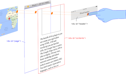
This plugin generates native map views, and puts them under the browser.
The map views are not HTML elements. This means that they are not a <div> or anything HTML related.
But you can specify the size and position of the map view using its containing <div>.
This plugin changes the background to transparent in your application.
Then the plugin detects your touch position, which is either meant for the native map or an html element
(which can be on top of your map, or anywhere else on the screen).

The benefit of this plugin is the ability to automatically detect which HTML elements are over the map or not.
For instance, in the image below, say you tap on the header div (which is over the map view). The plugin will detect whether your tap is for the header div or for the map view and then pass the touch event appropriately.
This means you can use the native Google Maps views similar to HTML elements.
-
Google+ : (managed by @wf9a5m75)
-
Gitter : (managed by @Hirbod)