![]()
![]()
![]()
![]()
Haftungsausschluss: Dieses Repository und die zugehörige Datenbank befinden sich derzeit in einer Beta-Version. Einige Aspekte des Codes und der Daten können noch Fehler enthalten. Bitte kontaktieren Sie uns per E-Mail oder erstellen Sie ein Issue auf GitHub, wenn Sie einen Fehler entdecken.
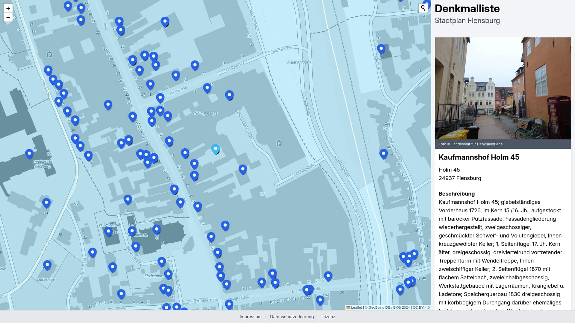
Die Idee, Denkmäler und deren Merkmale auf einer digitalen Karte anzuzeigen, ist während eines Spaziergangs durch Flensburg entstanden. Auf dem Open Data Portal Schleswig-Holstein stellt das Landesamt für Denkmalpflege Schleswig-Holstein eine Denkmalliste zur Verfügung, jedoch leider ohne Angabe der Koordinaten. Wir haben uns entschieden, dies zu ändern und einen Prototypen der Öffentlichkeit zugänglich zu machen, indem wir die Einträge mit den Gebäudekoordinaten ergänzen.
Das Landesamt für Denkmalpflege Schleswig-Holstein prüft anhand der gesetzlich vorgegebenen Kriterien den besonderen Wert eines Kulturdenkmals und legt die Maßstäbe, die Methodik für die Erfassung und Pflege sowie den Schutzumfang der Kulturdenkmale fest. Die erhobenen Daten der Denkmalliste werden im Open Data Portal des Landes Schleswig-Holstein zum Download angeboten. Die Kartendarstellung wurde von engagierten Einwohner:innen und ehrenamtlichen Mitgliedern des OK Lab Flensburgs entwickelt.
Du kannst jederzeit ein Issue auf GitHub öffnen oder uns über oklabflensburg@grain.one schreiben
Install system dependencies and clone repository
sudo apt install wget
sudo apt install git git-lfs
sudo apt install python3 python3-pip python3-venv

sudo sh -c 'echo "deb http://apt.postgresql.org/pub/repos/apt $(lsb_release -cs)-pgdg main" > /etc/apt/sources.list.d/pgdg.list'
wget -qO- https://www.postgresql.org/media/keys/ACCC4CF8.asc | sudo tee /etc/apt/trusted.gpg.d/pgdg.asc &>/dev/null
sudo apt update
sudo apt install postgresql-16 postgis
sudo apt install gdal-bin

# install NVM (Node Version Manager)
curl -o- https://raw.githubusercontent.com/nvm-sh/nvm/v0.39.7/install.sh | bash

# download and install Node.js
nvm install 20

# verifies the right Node.js version is in the environment
node -v

# verifies the right NPM version is in the environment
npm -v

git clone https://github.com/oklabflensburg/open-monuments-map.git
Create a dot .env file inside the project root. Make sure to add the following content and repace values.
BASE_URL=http://localhost

CONTACT_MAIL=mail@example.com
CONTACT_PHONE="+49xx"

PRIVACY_CONTACT_PERSON="Firstname Lastname"

ADDRESS_NAME="Address Name"
ADDRESS_STREET="Address Street"
ADDRESS_HOUSE_NUMBER="House Number"
ADDRESS_POSTAL_CODE="Postal Code"
ADDRESS_CITY="City"

DB_PASS=postgres
DB_HOST=localhost
DB_USER=postgres
DB_NAME=postgres
DB_PORT=5432
git pull
git lfs pull
Run sql statements inside open-monuments-map root directory
sudo -i -Hu postgres psql -U postgres -h localhost -d postgres -p 5432 < data/denkmalliste_schema.sql
sudo -i -Hu postgres psql -U postgres -h localhost -d postgres -p 5432 < data/denkmalliste_geometrien_schema.sql
Next add administrative geometries
ogr2ogr -f "PostgreSQL" PG:"dbname=postgres user=postgres port=5432 host=localhost" "data/vg250gem.geojson" -nln vg250gem
ogr2ogr -f "PostgreSQL" PG:"dbname=postgres user=postgres port=5432 host=localhost" "data/vg250vwg.geojson" -nln vg250vwg
ogr2ogr -f "PostgreSQL" PG:"dbname=postgres user=postgres port=5432 host=localhost" "data/vg250krs.geojson" -nln vg250krs
ogr2ogr -f "PostgreSQL" PG:"dbname=postgres user=postgres port=5432 host=localhost" "data/vg250lan.geojson" -nln vg250lan
ogr2ogr -f "PostgreSQL" PG:"dbname=postgres user=postgres port=5432 host=localhost" "data/vg250rbz.geojson" -nln vg250rbz
ogr2ogr -f "PostgreSQL" PG:"dbname=postgres user=postgres port=5432 host=localhost" "data/vg250sta.geojson" -nln vg250sta
Next initialize python virtualenv and install the dependencies
cd tools
python3 -m venv venv
source venv/bin/activate
pip install -r requirements.txt
python insert_monuments.py ../data/stadt-flensburg-denkmalschutz.geojson
python insert_boundaries.py ../data/denkmalliste_geometrien.geojson
python insert_nearest.py
deactivate
To query a boundary of an monument call this script with an object_id
./query_boundaries.py 4677
{"crs": {"properties": {"name": "urn:ogc:def:crs:OGC:1.3:CRS84"}, "type": "name"}, "features": [{"geometry": {"coordinates": [[[10.473906, 54.268938], [10.474305, 54.268966], [10.474323, 54.268879], [10.473924, 54.26885], [10.473906, 54.268938]]], "type": "Polygon"}, "properties": {"object_id": "4677"}, "type": "Feature"}], "type": "FeatureCollection"}To query an administrative geometry with a buffer by 350 meters
./query_geojson.py Wiedenborstel
{"crs": {"properties": {"name": "urn:ogc:def:crs:OGC:1.3:CRS84"}, "type": "name"}, "features": [{"geometry": {"coordinates": [[[9.737154, 54.041516], [9.736735, 54.042374], [9.736698, 54.042454], [9.73641, 54.04311], [9.735614, 54.04376], [9.735067, 54.044321], [9.734727, 54.044936], [9.734607, 54.045578], [9.734713, 54.046222], [9.735041, 54.046839], [9.735567, 54.047561], [9.736286, 54.048271], [9.740882, 54.051691], [9.741717, 54.052187], [9.743463, 54.053016], [9.74434, 54.053355], [9.745311, 54.053586], [9.746341, 54.053701], [9.749554, 54.053872], [9.751125, 54.054024], [9.753842, 54.054889], [9.754684, 54.055104], [9.755576, 54.055232], [9.756492, 54.055267], [9.757405, 54.05521], [9.759331, 54.05499], [9.760373, 54.054875], [9.764946, 54.056171], [9.765929, 54.056382], [9.766964, 54.056477], [9.76801, 54.056451], [9.769028, 54.056306], [9.775747, 54.054924], [9.777342, 54.05468], [9.778022, 54.054546], [9.781149, 54.053792], [9.781931, 54.053557], [9.782638, 54.05325], [9.783249, 54.05288], [9.784607, 54.051908], [9.784754, 54.051882], [9.785748, 54.051635], [9.786637, 54.051276], [9.787386, 54.050819], [9.787964, 54.050283], [9.788347, 54.04969], [9.788519, 54.049063], [9.788475, 54.048429], [9.788215, 54.047813], [9.787751, 54.047241], [9.7871, 54.046734], [9.785562, 54.04576], [9.783264, 54.043586], [9.782619, 54.043092], [9.781822, 54.042683], [9.7803, 54.042047], [9.779656, 54.040915], [9.779787, 54.040433], [9.779846, 54.040122], [9.779886, 54.039726], [9.78002, 54.039524], [9.780258, 54.039063], [9.780374, 54.038585], [9.780446, 54.03793], [9.780402, 54.037279], [9.780132, 54.036647], [9.779647, 54.036062], [9.779603, 54.036028], [9.779602, 54.035886], [9.779406, 54.035298], [9.779023, 54.034742], [9.777706, 54.033252], [9.777245, 54.032835], [9.777613, 54.031175], [9.777649, 54.030577], [9.777491, 54.029986], [9.777146, 54.029423], [9.776626, 54.028909], [9.77595, 54.028462], [9.775143, 54.028098], [9.774233, 54.027832], [9.771954, 54.027315], [9.77094, 54.027151], [9.769892, 54.027107], [9.768849, 54.027184], [9.767852, 54.02738], [9.76694, 54.027687], [9.766147, 54.028094], [9.765478, 54.028511], [9.763896, 54.028982], [9.763092, 54.028924], [9.762064, 54.028967], [9.762057, 54.028968], [9.761934, 54.028946], [9.760942, 54.028876], [9.759945, 54.028916], [9.758979, 54.029064], [9.758076, 54.029316], [9.757269, 54.029662], [9.756765, 54.029924], [9.756706, 54.029931], [9.754993, 54.029853], [9.754097, 54.029856], [9.753215, 54.029948], [9.746759, 54.030951], [9.742702, 54.031582], [9.741743, 54.031791], [9.740869, 54.032104], [9.740112, 54.032509], [9.7395, 54.032991], [9.739056, 54.033534], [9.738795, 54.034116], [9.738727, 54.034716], [9.738855, 54.035314], [9.739242, 54.036329], [9.739018, 54.03652], [9.738161, 54.037511], [9.738113, 54.037568], [9.73724, 54.038632], [9.736843, 54.039296], [9.736707, 54.039995], [9.736839, 54.040694], [9.737154, 54.041516]]], "type": "Polygon"}, "properties": {"gen": "Wiedenborstel"}, "type": "Feature"}], "type": "FeatureCollection"}SELECT
json_build_object(
'type', 'FeatureCollection',
'crs', json_build_object(
'type', 'name',
'properties', json_build_object(
'name', 'urn:ogc:def:crs:OGC:1.3:CRS84'
)
),
'features', json_agg(
json_build_object(
'type', 'Feature',
'geometry', ST_AsGeoJSON(m.wkb_geometry)::json,
'properties', json_build_object(
'object_id', m.object_id,
'place_name', m.place_name,
'address', m.address,
'postal_code', m.postal_code,
'image_url', m.image_url,
'designation', m.designation,
'description', m.description,
'monument_type', m.monument_type,
'reasons', (
SELECT string_agg(mr.label, ', ')
FROM monument_reason AS mr
WHERE mxr.monument_id = m.id
)
)
)
)
)
FROM monuments AS m
JOIN monument_x_reason AS mxr ON mxr.monument_id = m.id
JOIN monument_reason AS mr ON mxr.reason_id = mr.id
JOIN vg250gem AS v ON ST_Within(ST_GeomFromEWKB(m.wkb_geometry), ST_GeomFromEWKB(v.wkb_geometry))
WHERE LOWER(v.gen) = 'flensburg';